Violet Jessop, the 20th Century Lady Jonah: Part 2 – Aboard the RMS Titanic


.
Myself . 

By T.V. Antony Raj
.

Titanic - A painting by Ken Marschall
Titanic – A painting by Ken Marschall

.

In 1911, RMS Titanic was the second of three Olympic class ocean liners owned and operated by the White Star Line of steamships. It was the largest ocean cruiser afloat at the time it entered service.

Harland and Wolff built the ship in their shipyard on Queen’s Island, now known as the Titanic Quarter, in Belfast Harbour. Thomas Andrew, the managing director and head of the drafting department for the shipbuilding company was her naval architect in charge of the plans for the ocean liner. It took about 26 months to build it. Although RMS Titanic was virtually identical to the class lead ship RMS Olympic, a few modifications were made to differentiate the two ships.

.

RMS Titanic departing Southampton on April 10, 1912. Author: F.G.O. Stuart (1843-1923)

.
RMS Titan
ic was launched at 12:15 pm on May 31, 1911, in the presence of Lord William Pirrie  a leading Irish shipbuilder and businessman, J. Pierpoint Morgan  an American financier and banker, and J. Bruce Ismay (son of Thomas  Henry Ismay)  chairman and managing director of the White Star Line of steamships, and 100,000 onlookers. It is alleged that 22 tons of soap and tallow were spread on the slipway to lubricate the vessel’s passage into the River Lagan.

Captain Edward John Smith, RD, RNR

Captain Edward John Smith, RD, RNR

.
Edward John Smith, RD, RNR (January 27, 1850 – April 15, 1912) joined the White Star Line in March 1880 as the Fourth Officer of SS Celtic. He served aboard the company’s liners to Australia and to New York City and quickly rose in status. In 1887, he received his first White Star command, the SS Republic. From 1895 on, Smith was captain of SS Majestic for nine years.

He gained a reputation among his passengers and crew members for his quiet pomposity. Most England’s elite preferred to traverse the Atlantic only in a ship captained by him, thus he became known as the “Millionaires’ Captain“.

From 1904 on, Smith commanded the White Star Line’s newest ships on their maiden voyages. In 1904, he was given command of the then-largest ship in the world, the RMS Baltic. Her maiden voyage from Liverpool to New York, that set sail on June 29, 1904, went without incident. After three years with RMS Baltic, Smith was given his second new big ship, the RMS Adriatic and once again the maiden voyage went without any untoward incident.

Onboard the RMS Titanic

Violet Jessop was one of the happiest stewardesses while working on the Olympic. But, after the Hawke incident, she was apprehensive in joining as a stewardess on any ship. However, her friends persuaded her to join the heavily advertised ‘unsinkable’ Titanic as they thought it would be a ‘wonderful experience’ to serve on her.

On April 10, 1912, Violet, ‘dressed in a new ankle-length brown suit’ set out in a horse-drawn Hansom cab to join the brand new ship as a stewardess at her berth in Southampton. The same day RMS Titanic left Southampton on its maiden voyage to New York.

Bruce Ismay usually accompanied his ships on their maiden voyages, and the Titanic was one of them.

There were 908 crew members, including Violet Jessop onboard the RMS Titanic under the command of Captain Edward Smith. Most of the crew members were not seamen. They were divided into three principal departments: Deck, Engine, and Victualling. Of these crew members, only 23 were female, mainly stewardesses.

Also among the crew were bakers, chefs, butchers, fishmongers, dishwashers, stewards, gymnasium instructors, laundrymen, waiters, bed-makers, cleaners, etc. The ship even had a printer, who produced a daily newspaper for passengers called the Atlantic Daily Bulletin with the latest news received by the ship’s wireless operators.

Southampton is a major port and the largest city on the south coast of England. Out of the 908 crew members, 699 of the crew came from Southampton, and 40% were natives of the city. Most of the crew signed on in Southampton on April 6, 1912.

Some specialist crew members were self-employed or were subcontractors. There were: five postal clerks, who worked for the Royal Mail and the United States Post Office Department; the staff of the First Class À La Carte Restaurant and the Café Parisien; the radio operators, employed by Marconi; and the eight musicians employed by an agency and travelling as second-class passengers. Violet says she became a friend of the Scottish violinist, Jock Hume.

The pay of crew members varied greatly. Captain Edward Smith was paid £105 a month. Violet Jessop and the other stewardesses were paid £3 10s. The lower-paid victualling staff were allowed to supplement their wages through tips from passengers.

In the late 19th and early 20th centuries, millions of Europeans immigrated to the United States and Canada. White Star was among the first shipping lines to have passenger ships with inexpensive accommodation for third-class passengers, in addition to luxury first-class and second-class berths. The White Star Line’s quartet of revolutionary liners had the largest carrying capacity for third-class passengers: RMS Celtic of 1901 had a capacity for 2,352 passengers; RMS Cedric of 1903 and RMS Baltic of 1904 had a capacity for 2,000 passengers each, and RMS Adriatic of 1907 had a capacity for 1,900 passengers.

The passengers on RMS Titanic included some of the wealthiest people in the world: 325 first-class and 285 second-class passengers, as well as 706 third-class passengers – mostly emigrants from Great Britain, Ireland, Scandinavia and from countries throughout Europe seeking a new life in North America.

The following photos are from scenes enacted by actors for the play TITANIC at the Barrow-Civic Theatre, at 1223 Liberty Street, Franklin, Pennsylvania, USA.

.

TITANIC - First Class Passengers. (Source: titanic-bct.blogspot.in)
TITANIC – First Class Passengers. (Source: titanic-bct.blogspot.in)

.

TITANIC - Second Class Passengers. (Source: titanic-bct.blogspot.in)
TITANIC – Second Class Passengers. (Source: titanic-bct.blogspot.in)

.

TITANIC - Third Class Irish Immigrants (Source: titanic-bct.blogspot.in)
TITANIC – Third Class Irish Immigrants (Source: titanic-bct.blogspot.in)

.

The proud serivce staff of the RMS TITANIC (from left to right) Stewardess Annie Robinson, Stewardess Violet Jessop, Head Steward Henry Etches, Mrs. Latimer, and Stewardess Mary Hutchinson. (Source: titanic-bct.blogspot.in)
The proud serivce staff of the RMS TITANIC (from left to right) Stewardess Annie Robinson, Stewardess Violet Jessop, Head Steward Henry Etches, Mrs Latimer, and Stewardess Mary Hutchinson. (Source: titanic-bct.blogspot.in)

.
On April 10, 1912, at noon RMS Titanic left Southampton on its maiden voyage to New York. She called at Cherbourg in France at 6:35 pm. After disembarking 15 first and seven second class passengers, the ship took aboard 142 first, 30 second and 102 third class passengers. It left Cherbourg at 8:10 pm for Queenstown (now Cobh) in Ireland.

The ship reached Queenstown at 11:30 am. After disembarking and embarking passengers, she set out at 1:30 pm on her fatal voyage towards New York with a total of 2,224 people: 908 crew members, 325 first class, 285 second class and 706 third class passengers.
.

RMS Titanic, painted by 16-year-old Ken Marschall (Source : greenwichworkshop.com)
RMS Titanic, painted by 16-year-old Ken Marschall (Source: greenwichworkshop.com)

.
In her memoirs, Violet Jessop mentions Thomas Andrews, the naval architect in charge of the plans for the ocean liner RMS Titanic. Like all other crew members, she too greatly admired him for he was the only person who heeded the requests of the crew for improvements in their quarters. She wrote:

“Often during our rounds, we came upon our beloved designer going about unobtrusively with a tired face but a satisfied air. He never failed to stop for a cheerful word, his only regret that we were ‘getting further from home.‘ We all knew the love he had for that Irish home of his and suspected that he longed to get back to the peace of its atmosphere for a much-needed rest and to forget ship designing for a while.”

During the voyage, Bruce Ismay talked about a possible test of speed if time permitted.

.

 Previous: Part 1 – Aboard the RMS Titanic

Next → Part 3 – Ice Warnings for the The RMS Titanic 

.

.

Add this anywhere

Enhanced by Zemanta

Violet Jessop, the 20th Century Lady Jonah: Part 1 – Aboard the RMS Olympic


.
Myself . By T.V. Antony Raj
.

Jonah

.
The Biblical narrative of Jonah in the Old Testament, set in or around the 8th century BC, concerns the disobedient prophet, Jonah. God orders Jonah: “Set out for the great city of Nineveh, and preach against it; for their wickedness has come before me.

But Jonah chose to flee “away from the LORD” to Tarshish by sea, geographically in the opposite direction. He went down to Joppa, found a ship going to Tarshish. The LORD, however, hurled a great wind upon the sea, and the storm was so great that the ship was about to break up. Then, the sailors were afraid and each one cried to his god. To lighten the ship they threw its cargo into the sea. The sailors cast lots, and the lot fell on Jonah. Jonah admitted his disobedience to God.

The sailors asked, “What shall we do with you, that the sea may calm down for us?

Jonah responded, “Pick me up and hurl me into the sea and then the sea will calm down for you. For I know that this great storm has come upon you because of me.”

Since the sea was growing more and more stormy they picked up Jonah and hurled him into the sea, and the sea stopped raging. But the LORD sent a great fish to swallow Jonah, and he remained in the belly of the fish three days and three nights. Jonah prayed to God in his affliction. God commanded the fish to spew Jonah out.
.

Violet Constance Jessop (October 2, 1887 – May 5, 1971)

..

Violet Constance Jessop (October 2, 1887 – May 5, 1971) was an ocean liner stewardess and nurse notable for surviving the disasters associated with the British White Star Line’s trio of Olympic-class liners: RMS Olympic, RMS Titanic and HMHS Britannic.

Was Violet Jessop a 20th century Lady Jonah?

In the mid 1880s, her father, William Jessop immigrated to the Argentine Republic from Dublin to try his hand at sheep farming. In 1886, his fiancée, Katherine Kelly from Dublin joined him.

Violet Jessop was the first of nine children born to them. Violet contracted tuberculosis at an early age. However, she survived even though her doctor predicted that she would succumb to the illness. Despite a delayed education, Violet benefited from an American schooling in Argentina.

.

SS Orinoco (Source: clydesite.co.uk)

.

After William Jessop died in Mendoza, Katherine Kelly moved to Great Britain with her children where she found a job as a stewardess for the Royal Mail Line. Violet attended a convent school under the tutelage of Breton nuns in Kent.

When Katherine became ill, Violet left school at an early age to act as a parental surrogate to four younger brothers. Like her mother, Violet decided to become a ship stewardess.

In the early 20th century, most women working as stewardesses were middle-aged, but Violet just 21-years-old and looked beautiful which proved to be a disadvantage in finding a position as a stewardess because Employers believed that her youth and good looks would cause problems with the crew and passengers. Violet solved the problem by making herself look homely by wearing old clothes and no makeup while attending interviews.

In 1908, Violet joined as a stewardess aboard the Royal Mail Line’s passenger-cargo vessel the SS Orinoco that plied between Southampton and the West Indies. From then on, her seagoing career continued with few interruptions for 42 years.
.

Titanic Survivor

.

John Maxtone-Graham the editor of “Titanic Survivor: The Newly Discovered Memoirs of Violet Jessop Who Survived both the Titanic and Britannic Disasters,” said her beauty increased her troubles with the “philandering captains and pursers, loquacious or insufferable fellow stewardesses, and an array of sometimes horrifying passengers.

During her career as a stewardess on various ships, at least three men proposed to her, of while one was an incredibly wealthy first-class passenger.

The White Star Line and Harland & Wolff

Harland & Wolff Heavy Industries Limited in Belfast, Northern Ireland, is a Northern Irish heavy industrial company, specializing in shipbuilding and offshore construction. The company was formed in 1861 by Edward James Harland and Hamburg-born Gustav Wilhelm Wolff, who lived in the United Kingdom from age 14.

The Belfast shipbuilders had a long-established relationship dating back to 1867 with the White Star Line founded in Liverpool, England, by John Pilkington and Henry Wilson in 1845.

White Star Line concentrated on the Liverpool to New York shipping services. They financed their heavy investment in new ships by borrowing from the Royal Bank of Liverpool. The bank failed in October 1867 leaving White Star Line with an overwhelming debt of £527,000 (£39,510,442 as of 2014) and forced into bankruptcy.
.

White Star Line vector logo

On January 18, 1868, Thomas Henry Ismay, a director of the National Line, purchased the house flag, trade name and goodwill of the bankrupt company for £1,000, (£76,182 as of 2014) intending to operate large ships on the North Atlantic service.

Thomas Ismay was president of White Star Line till 1899 and had several ships under his authority. Most of these ships were chartered.

Gustav Christian Schwabe, a prominent Liverpool merchant, and his nephew, Gustav Wilhelm Wolff, approached Thomas Ismay during a game of billiards. Schwabe offered to finance the new line if Ismay had his ships built by Wolff’s company, Harland & Wolff.

Thomas Ismay agreed and established a partnership with the agreement with the stipulation that the shipbuilders would not build any vessels for the rivals of White Star Line. Harland and Wolff were given a great deal of latitude in designing ships for the White Star Line. Cost considerations were relatively low on the agenda and the shipbuilders were authorized to spend whatever on the ships and would be paid cost plus a fixed five percent profit margin.

White Star Line placed their first order with Harland & Wolff on July 30, 1869 and began operating again in 1871 between New York and Liverpool, with a call at Queenstown.

It has long been a custom with many shipping lines to have a common theme for the names of their ships. White Star Line named their ships ending in –ic.

In the late 19th century, White Star Line sought to fund construction of two ships, SS Majestic and SS Teutonic through the British government. The government accepted the proposition with the stipulation that the Royal Navy would have access to the two ocean liners in a time of war.

.

SS Majestic (1890)
SS Majestic (1890)

.

Harland & Wolff built SS Majestic for White Star Line and launched her on June 29, 1889. After fitting the ship during the next nine months, it was delivered to White Star Line in March, 1890. On April 2, 1890, SS Majestic left Liverpool on her maiden voyage to New York.

In 1895, 45-year-old English naval reserve officer Edward John Smith, who years later would gain lasting fame as the captain of the RMS Titanic was given command of SS Majestic. He served as her captain for nine years. When the Boer War started in 1899, SS Majestic under Smith’s command transported troops to Cape Colony. The ship made two trips to South Africa, in December 1899 and in February 1900, without any adverse incident.

Thomas Ismay died on November 23, 1899 and his son J. Bruce Ismay succeeded him as the chairman of White Star Line. He decided to build four ocean liners to surpass the RMS Oceanic built by his father: the ships were dubbed the ‘Big Four’: RMS Celtic, RMS Cedric, RMS Baltic, and RMS Adriatic. These vessels were designed more for luxury and for speed than safety.

In 1902, J.P. Morgan & Co., was organizing the formation of the International Mercantile Marine Company (IMM). It was an Atlantic shipping combine which absorbed several major American and British lines. Bruce Ismay negotiated the sale of the White Star Line to J.P. Morgan&Co. The White Star Line became one of the IMM operating companies. In February 1904, Bruce Ismay became president of the IMM, with the support of Morgan.

Violet Jessop’s Career with White Star Line

After a brief assignment aboard SS Orinoco, Violet Jessop was hired by the White Star Line as a stewardess aboard SS Majestic.

In the early 20th century, the Harland & Wolff shipyard built a trio of ocean liners for the White Star Line, which were popularly called the Olympic-class ocean liners. They were: RMS Olympic, RMS Titanic and RMS Britannic.

The designs for both Olympic and Titanic were on the board at the same time. However, to ease pressures on the shipyard, construction of the Olympic began three months before Titanic. Several years would pass before Britannic would be launched.

In 1912, the trio were by far the largest vessels of the White Star Line’s fleet of 29 steamers and tenders.

The RMS Olympic

RMS Olympic built by Harland & Wolff was the lead ship and the namesake of the White Star Line’s trio of Olympic-class liners. Launched on October 20, 1910, it was the largest civilian transatlantic luxury ocean liner at that time – nearly 100 feet (30 meters) longer than any other ship. Edward Smith, who had earned the reputation as one of the world’s most experienced sea captains was given the first command of the lead ship.

.

RMS Olympic arriving at New York on her maiden voyage in June 1911.

.

The maiden voyage of RMS Olympic from Southampton to New York concluded successfully on June 21, 1911. However, as the ship was docking at Pier 59 in New York harbor under the command of Captain Smith with the assistance of a harbor pilot, one of the 12 assisting tugs got caught in the backwash of Olympic, collided with the ship, and for a brief moment was trapped under Olympic‘s stern. Eventually, the tug managed to free itself and limped to the docks.

During World War I, RMS Olympic served as a troopship and was fondly remembered as the “Old Reliable“. After the war, it returned to civilian service. Throughout the 1920s and in the first half of the 1930s, she served as an ocean liner. She was in service for 24 years from 1911 to 1935. After 1930, the slump in trade during the Great Depression, and increased competition, made her operation increasingly unprofitable for the White Star Line.

On June 14, 1911, the 23-year-old Violet Jessop boarded the RMS Olympic to work as a stewardess on it.

Three months later, on September 20, 1911, shortly after leaving Southampton at the start of her planned fifth voyage to New York, RMS Olympic collided with the old protected Royal Navy cruiser HMS Hawke off the Isle of Wight, the largest island of England in the English Channel.

At the time of this incident Violet Jessop was on board the RMS Olympic.

.Satellite image showing the Solent, separating the Isle of Wight from mainland England (Source: Earth Sciences and Image Analysis, NASA-Johnson Space Center)

Satellite image showing the Solent, separating the Isle of Wight from mainland England (Source: Earth Sciences and Image Analysis, NASA-Johnson Space Center).

The collision took place as RMS Olympic and HMS Hawke were running parallel to each other through the Solent. The wide radius taken by RMS Olympic to turn to starboard took the commander of the HMS Hawke by surprise and its bow designed to sink ships by ramming, tore two large gashes on the RMS Olympic‘s starboard side, one above and one below the waterline resulting in the flooding of two of her watertight compartments and a twisted propeller shaft.

.

The damage to RMS Olympic (Source: Popular Mechanics Magazine December 1911)
The damage to RMS Olympic and HMS Hawke (Source: Popular Mechanics Magazine December 1911)

.

HMS Hawke nearly capsized after she sustained severe damage to her bow.

Despite the heavy damage to both vessels, there were no casualties and none seriously injured.

Both vessels managed to steam back to Southampton for repairs. The fifth voyage of RMS Olympic to New York was cancelled.

After two weeks of temporary repairs in Southampton, RMS Olympic returned to Belfast for further repairs. On 30th November 1911, she returned to active service.

Though Violet Jessop survived the collision of RMS Olympic with the HMS Hawke, she was slated for more traumatic experience a year later on RMS Titanic and on the RMS Britannic in 1916.

Next Part 2 – Aboard the RMS Titanic

.

.

Enhanced by Zemanta

Add this anywhere

Mystery of Malaysia Airlines Flight MH370 – Inmarsat’s Satellite Data


.Myself

By T. V. Antony Raj

Wild ride of MH370 (Source: heraldsun.com.au)

.

The search for the missing Malaysia Airlines Flight MH370 is now on in a section of the southern Indian Ocean known as the “Roaring Forties” where strong westerly winds generally blow between latitude 40° and 50°. The strong west-to-east air currents are induced by the combination of the Earth’s rotation and air being displaced from the Equator towards the South Pole, with just a few landmasses to act as windbreaks. The area is characterized by cold fronts that sweep east every four to five days, causing  13 to 30 feet (4 to 9 meters) pounding waves that churn the icy sea.

International Mobile Satellite Organization (Inmarsat) is a British satellite telecommunications company, offering global, mobile services. Inmarsat started playing an import role immediately after Malaysian Airlines Flight MH370 disappeared.

One of Inmarsat’s satellites continued to pick up a series of automated hourly ‘pings’ from the missing aircraft which would normally be used to synchronize timing information even after the Aircraft Communications Addressing and Reporting System (ACARS), which would usually transmit the plane’s position, was switched off, suggesting the plane flew to the Indian Ocean.

.

How Inmarsat tracked down Flight MH370 (Source: telegraph.co.uk)

.

By analyzing these pings, Inmarsat established that the aircraft continued to fly for at least five hours after the aircraft left Malaysian airspace and that it had flown along one of two ‘corridors’ – one arcing north and the other south. The plane was reportedly flying at a cruising height above 30,000 feet. See my article “Mystery of Malaysia Airlines Flight MH370 – If Hijacked, Where Did It Go?

Using complex mathematical processes, Inmarsat’s engineers analyzed the tiny shifts in the frequency of the pings from the missing aircraft and came up with a detailed Doppler effect model for the northern and southern paths and inferred the aircraft’s likely final location though their method had never been used before to investigate an air disaster.

Chris McLaughlin, senior vice-president of external affairs at Inmarsat said:

“We looked at the Doppler effect, which is the change in frequency due to the movement of a satellite in its orbit. What that then gave us was a predicted path for the northerly route and a predicted path the southerly route…

That’s never been done before; our engineers came up with it as a unique contribution… By yesterday they were able to definitively say that the plane had undoubtedly taken the southern route…

We worked out where the last ping was, and we knew that the plane must have run out of fuel before the next automated ping, but we didn’t know what speed the aircraft was flying at – we assumed about 450 knots. We can’t know when the fuel actually ran out, we can’t know whether the plane plunged or glided, and we can’t know whether the plane at the end of the time in the air was flying more slowly because it was on fumes.”

.

Pings to Inmarsat (video grab from Wall Street Journal)

.

According to the Wall Street Journal, Inmarsat relayed their findings to the Malaysian officials and the British security and air-safety officials on March 12, 2014. But the Malaysian government concerned about corroborating the data and dealing with internal disagreements about how much information to release did not publicly acknowledge Inmarsat’s information until four days later. On Saturday, March 15, 2014, during a news conference, Malaysian Prime Minister Najib Razak accepted for the first time that deliberate actions were involved in the disappearance of the aircraft. He said:

“Based on new satellite information, we can say with a high degree of certainty that the Aircraft Communications Addressing and Reporting System (ACARS) was disabled just before the aircraft reached the east coast of Peninsular Malaysia. Shortly afterwards, near the border between Malaysian and Vietnamese air traffic control, the aircraft’s transponder was switched off.”

 He added that the search effort was redirected from that day to focus on the areas the Inmarsat information described:

“From this point onwards, the Royal Malaysian Air Force primary radar showed that an aircraft which was believed – but not confirmed – to be MH370 did indeed turn back. It then flew in a westerly direction back over Peninsular Malaysia before turning north-west. Up until the point at which it left military primary radar coverage, these movements are consistent with deliberate action by someone on the plane.

Today, based on raw satellite data that was obtained from the satellite data service provider, we can confirm that the aircraft shown in the primary radar data was flight MH370. After much forensic work and deliberation, the F.A.A., N.T.S.B., A.A.I.B. and the Malaysian authorities, working separately on the same data, concur.

According to the new data, the last confirmed communication between the plane and the satellite was at 8:11 a.m. Malaysian time on Saturday 8th March. The investigations team is making further calculations which will indicate how far the aircraft may have flown after this last point of contact. This will help us to refine the search.

Due to the type of satellite data, we are unable to confirm the precise location of the plane when it last made contact with the satellite.

However, based on this new data, the aviation authorities of Malaysia and their international counterparts have determined that the plane’s last communication with the satellite was in one of two possible corridors: a northern corridor stretching approximately from the border of Kazakhstan and Turkmenistan to northern Thailand, or a southern corridor stretching approximately from Indonesia to the southern Indian Ocean. The investigation team is working to further refine the information.

In view of this latest development, the Malaysian authorities have refocused their investigation into the crew and passengers on board. Despite media reports that the plane was hijacked, I wish to be very clear: we are still investigating all possibilities as to what caused MH370 to deviate from its original flight path.

This new satellite information has a significant impact on the nature and scope of the search operation. We are ending our operations in the South China Sea and reassessing the redeployment of our assets. We are working with the relevant countries to request all information relevant to the search, including radar data.

As the two new corridors involve many countries, the relevant foreign embassies have been invited to a briefing on the new information today by the Malaysian Foreign Ministry and the technical experts. I have also instructed the Foreign Ministry to provide a full briefing to foreign governments which had passengers on the plane. This morning, Malaysia Airlines has been informing the families of the passengers and crew of these new developments.”

On March 18, 2014, Australia and the US National Transportation Safety Board narrowed down the search area to just three per cent of the southern corridor by taking into consideration Inmarsat’s inference from the satellite pings, along with assumptions about the plane’s speed.

On Monday, March 24, 2014, Prime Minister Najib Razak said that according to Inmarsat the aircraft flew along the southern corridor and ended its journey in the middle of the southern Indian Ocean. He said:

“Based on new analysis… MH370 flew along the southern corridor and that its last position was in the middle of the Indian Ocean west of Perth… It is therefore, with deep sadness and regret, that I must inform you that according to this new data that flight MH370 ended in the southern Indian Ocean.”

On the same day, Australian and Chinese search planes separately spotted a few objects in the southern Indian Ocean and alleged they were possible debris from the missing aircraft and reported the coordinates to the Australian Maritime Safety Authority (AMSA), which is coordinating the multinational search, and also to the Chinese icebreaker Snow Dragon, which is en route to the area. Half a dozen other Chinese ships along with 20 fishing vessels have been ordered to move toward the search zone.

Australian Prime Minister Tony Abbott said the crew of an Australian P3 Orion plane had located and two objects in the search zone, but it was unclear if they were part of an aircraft. He said the first object was grey or green and circular, the second orange and rectangular. The crew was able to photograph the objects.

.

Search suspended ... this satellite image shows severe tropical cyclone Gillian off the Western Australian coast. Credit: Bureau of Meteorology
Search suspended this satellite image shows severe tropical cyclone Gillian off the Western Australian coast. Credit: Bureau of Meteorology

.

An Australian Navy supply ship, the HMAS Success, was on the scene on Monday trying to locate and retrieve the objects. However, according to AMSA, due to rough seas, the vessel left the search area early Tuesday morning since conducting the search in such conditions would be hazardous and pose a risk to crews.AMSA said the vessel is now in transit south of the search area until the sea calms down and if weather conditions permit the search would be resumed tomorrow, otherwise, if weather conditions continue to deteriorate it could be several days before the search is resumed.

Meanwhile, the United States prepared to move into the region a special device that can locate black boxes.

.

RELATED ARTICLES

Enhanced by Zemanta

Mystery of Malaysia Airlines Flight MH370 – Were There Any Phone Calls from the Aircraft?


.

Myself By T.V. Antony Raj

There were 239 people on board the missing Malaysia Airlines Flight 370 that took off from the Kuala Lumpur International Airport, Kuala Lumpur, Malaysia, on March 8, 2014 at 00:41 MST.

On Saturday, March 22, 2014, The Telegraph published the cockpit communication aboard the missing Malaysia Airlines flight from its taxi on the runway to its final message at 1:19 am of ‘all right, good night‘. The transcript starts at 00.25 with general instructions from the control tower to the pilots. The detailed conversation begins at 00.36.

Transcript of the final 54 minutes of communication from Malaysia Airlines flight MH370 (Source: telegraph.co.uk)
Transcript of the final 54 minutes of communication from Malaysia Airlines flight MH370. (Source: telegraph.co.uk)

KL CONTROL TOWER
00:36:30
MH370: ATC, this is MH370, good morning
ATC: Good morning, MH370, This is KL control tower, please remain in A10 32R

00:36:50 MH370: A10, MH370 copies that

00:38:43
ATC: MH370, please get on the runway from 32R A10

MH370: runway from 32R A10, copy that

00:40:38
ATC: MH370, position 32R, runway ready, permitted to take
off. Good night
MH370: position 32R, runway ready, permitted to take off. MH370 copies that. Thank you, goodbye.

KL AIRPORT
00:42:05 MH370: MH370 has left the port

00:42:10 ATC: MH370 position confirmed, flight altitude 180, follow the command and turn right, target IGARI waypoint.

00:42:40 MH370: Alright, altitude 180, direction IGARI waypoint, MH370 copies that

00:42:52
ATC: MH370, you’ve entered KL Radar 132.6, good night
MH370: 132.6, MH370 copies that

KL RADAR
00:46:51
MH370: KL ATC, This is MH370

ATC: MH370, please climb to flight altitude 250

00:46:54 MH370: MH370 is climbing to flight altitude 250

00:50:06 ATC: MH370, climbing to flight altitude 350

00:50:09 MH370: This is MH370, flight altitude 350

01:01:14 MH370: MH370 remaining in flight altitude 350

01:01:19 ATC: MH370

01:07:55 MH370: MH370 remaining in flight altitude 350

01:08:00 ATC: MH370

01:19:24 ATC: MH370, please contact Hu Chi Minh City 120.9, good night

01:19:29 MH370: All right, good night

Today, everyone has a cellular phone and some would even have two phones. If so, there should have been a minimum of 250 cell phones among the 217 passengers and 12 crew members on board the missing aircraft.

In 1991, the Federal Communications Commission (FCC), an independent agency of the United States government, prohibited the use of cellular devices for making phone calls or surfing the Web in-flight by passengers while on board an airplane because the FCC suspected that the radio frequency emitted by cell phones could cause an airplane’s communication equipment to malfunction.

The Federal Aviation Administration (FAA), the national aviation authority of the United States, agrees with the FCC that cell phones may cause substantial interference with aircraft systems and supports the ban for all commercially operated airplanes. Many airlines comply with FCC’s rule. However, some commercial airlines have instituted different policies about when passengers can turn their cell phones on and off while on board their airplanes.

The use of cell phones on private or charter planes is not regulated, and many private flights permit passengers to use cell phones while in flight.

When United Flight 93 was hijacked on September 11, 2001, passengers managed to make two cell phone calls during the flight’s final minutes. Several other calls were made using air-phones.

In 2005, the FCC announced that it might consider lifting the ban on the use of cell phones on airplanes above 10,000 feet, with certain restrictions.

Latest cellular phones are able to operate on very low power settings, and may not interfere with the aircraft’s communication systems. The FCC is trying to establish an acceptable threshold of radio frequency emissions to allow cell phones to be used on airplanes without any fear of causing failure to the aircraft’s navigation system or disrupting service on the ground. These devices will still need to be in airplane mode during takeoff and landing.

Earlier, the European Commission allowed only 2G wireless services to be used aboard flights above 3,000 meters. In November 2013, the European Commission adopted new rules to allow passengers use devices with 3G and 4G data connections.

Now, the often asked question on social media is: “Did the passengers on board the missing Malaysia Airlines Flight 370 make calls using their cell phones?

On Monday, March 17, 2014,  at a news conference Malaysia Airlines CEO Ahmad Jauhari Yahya said: “So far, we have not had any evidence of any telephone company of any member trying to contact.”

One reason might be that once the aircraft cruises to a certain height the cell phones are no longer in the range of the cellular network because cell phone towers are not built to project their signals that high.

Was the Flight MH370 flying too high?

According to radar analysis, the plane had been flying as high as 45,000 feet and as low as 23,000 feet, which the experts say is too high to register with mobile towers.

Also, according to telecom experts, when the plane flies too fast the cell phone fails to register with cell towers. Typical cruise speed of a Boeing 777 aircraft is Mach 0.84 (560 mph, 905 kph, 490 knots) at a cruise altitude of 35,000 feet (11,000 meters).

Bill Rojas, director of telecom research at IDC Asia Pacific said that passengers travelling on high-speed trains in Japan and other countries manage to make telephone calls using 3G networks at speeds of up to 150 mph (240 kph) but cell towers do not register a signal beyond those speeds. According to Rojas the aircraft would need to have been flying at speeds below 155 mph (250 kph) and at an altitude less than 10,000 feet (3,050 meters) for passengers to make or receive calls.

.

RELATED ARTICLES

.

Enhanced by Zemanta

Add this anywhere

Mystery of Malaysia Airlines Flight MH370 – Hypothetical Theories


.

Myself By T.V. Antony Raj

From the day the Malaysia Airlines Flight MH370 disappeared many theories such as hijacking, disintegration in midair, missile attack, and so on, are being elucidated by pundits and amateurs for the possible disappearance of the flight that took off on Saturday, March 8, 2014, at 00:41 MST from the Kuala Lumpur International Airport with 239 people, including 12 crew members.

Since the international search for the missing aircraft has not yielded any result and the hope of finding it is waning as the days dawn on, implausible and whimsical theories are now circulating in regular and online social media.

A meteor strike?

Some have suggested that Malaysia Airlines Flight MH370 could have been struck by a powerful meteor that shattered it to smithereens, and the bits might have fallen into the sea.

Interception by aliens?

On the ForbiddenKnowledgeTV.com, a conspiracy theory site, Alexandra Bruce has interpreted the unusual data on Flightradar24.com on the date of the disappearance.  He suggests that a UFO might have intercepted the Malaysia Airlines Flight MH370.

The radar playback from Flightradar24.com website
The radar playback from Flightradar24.com website. Click image to view video.

Seeing the radar playback of the moments leading up to the plane’s disappearance, one may forgive Malaysia Airlines for not being more forward, in this case – because the radar playback is not only baffling, it shows two distinct anomalies, as pointed out by Intrepid citizen-reporter and YouTube popstar, DAHBOO7.

The radar playback depicts dozens of planes in flight over the region at the time. The first peculiarity is seen in the lower left of the screen. A round object appears in the vicinity of Flight 370 (and amid several others), which the radar does not automatically “read” as airplane. Suddenly, this round object take the form of a “plane” on the radar screen and accelerates at a rate of speed that must be at least five times the speed of the surrounding planes, heading eastward, over the South China Sea – and just as suddenly the object stops and appears to hover in place.

During this same time, there is some evidence that shortly after crossing the Malaysian Peninsula, Flight 370 was in trouble. The radar playback shows that the plane took three sharp turns: right, left, right at an altitude of 35,000 feet and at a speed of 473 knots – just before the radar readings instantly go from 35,000 feet to 0, with the plane still traveling at that speed for a few moments more, at 0 feet altitude before it vanishes from the screen. As of this writing, this plane remains missing, even though the sea is relatively shallow in the area where the lane went missing.

As for the other object described here, it disappears as well. There have been no reports about this object – or plane, or what have you; whether it was a commercial airliner, like the many others in flight during the final moments preceding the disappearance of Flight 370 – but the object in question certainly didn’t behave like a commercial airliner.

Regardless of whether or not this mystery object had anything to do with the demise of of Flight 370 – what IS evident is that the radar readings shown in this clip captured signals from what for now, can only be termed a UFO.

.

RELATED ARTICLES

.

Add this anywhere

Enhanced by Zemanta

Mystery of Malaysia Airlines Flight MH370 – Did the Aircraft Fly Towards Palau Langkawi


.

Myself . By T.V. Antony Raj

Malaysia Airlines Flight MH370  (Source: CNN)
Malaysia Airlines Flight MH370 (Source: CNN)

From the day the Malaysia Airlines Flight MH370 disappeared many theories such as hijacking, disintegration in midair, missile attack, and so on, are being elucidated by pundits and amateurs for the possible disappearance of the flight that took off on Saturday, March 8, 2014, at 00:41 MST from the Kuala Lumpur International Airport with 239 people, including 12 crew members.

The location of Malaysia Airlines Flight MH370 last seen on Air Traffic Control (ATC) radar at 02:40 MST (March 7, 18:40 UTC) was at 6°55′15″N 103°34′43″E. After that the aircraft ceased all communications. The aircraft’s transponder in the cockpit was switched off just before the plane passed from Malaysian to the Ho Chi Minh Area air traffic control space – the optimum moment, when the aircraft was not controlled by air traffic controllers in Malaysia or Vietnam. Later, authorities in Thailand and China informed their Malaysian counterparts that the aircraft had not entered their airspace.

On Saturday, March 15, 2014, a week after Malaysia Airlines Flight MH370 disappeared, Malaysian Prime Minister Najib Razak told reporters:

“Based on new satellite information, we can say with a high degree of certainty that the Aircraft Communications Addressing and Reporting System (ACARS) was disabled just before the aircraft reached the east coast of Peninsular Malaysia. Shortly afterwards, near the border between Malaysian and Vietnamese air traffic control, the aircraft’s transponder was switched off.”

The Prime Minister further said:

 “Despite media reports that the plane was hijacked, I wish to be very clear: we are still investigating all possibilities as to what caused MH370 to deviate from its original flight path.”

Chris Goodfellow
Chris Goodfellow

Chris Goodfellow, a Canadian with 20 years experience as a Class-1 instrumented-rated pilot for multi-engine does not speculate on terrorism, hijack, meteors, etc. He tries to look for a more simple explanation of this incident through his post “MH370  A different point of view. Pulau Langkawi 13,000 runway” on Google+.

When he heard reports that Malaysian military radar tracked the aircraft on a southwesterly course back across the Malay Peninsula into the straits of Malacca, he instantly brought up Google Earth and searched for airports in proximity to the track towards southwest.

Goodfellow suggests that the chief pilot was confronted by some major event on-board that made him turn back right away to the closest safe airport. It was probably a serious event and the crew in the cockpit must have been occupied trying to fight the fire and controlling the aircraft. For Goodfellw, the loss of transponders and communication makes perfect sense in the case of a fire and electrical short-circuit caused by the fire because the first reaction is to pull all the main busses and restore circuits, one by one, until the bad one is isolated and the aircraft would have gone silent. Aviate, Navigate and lastly communicate would be the modus operandi of a seasoned pilot.

Flight of MH370 to Langkawi

Chris Goodfellow says:

The left turn is the key here. This was a very experienced senior Captain with 18,000 hours. Maybe some of the younger pilots interviewed on CNN didn’t pick up on this left turn. We old pilots were always drilled to always know the closest airport of safe harbor while in cruise. Airports behind us, airports abeam us and airports ahead of us. Always in our head. Always. Because if something happens you don’t want to be thinking what are you going to do – you already know what you are going to do. Instinctively when I saw that left turn with a direct heading I knew he was heading for an airport. Actually he was taking a direct route to Palau Langkawi a 13,000 foot strip with an approach over water at night with no obstacles. He did not turn back to Kuala Lampur because he knew he had 8,000 foot ridges to cross. He knew the terrain was friendlier towards Langkawi and also a shorter distance.

What I think happened is that they were overcome by smoke and the plane just continued on the heading probably on George (autopilot) until either fuel exhaustion or fire destroyed the control surfaces and it crashed. I said four days ago you will find it along that route – looking elsewhere was pointless.

This pilot, as I say, was a hero struggling with an impossible situation trying to get that plane to Langkawi. No doubt in my mind. That’s the reason for the turn and direct route. A hijack would not have made that deliberate left turn with a direct heading for Langkawi. It would probably have weaved around a bit until the hijackers decided on where they were taking it.

Surprisingly none of the reporters , officials, other pilots interviewed have looked at this from the pilot’s viewpoint. If something went wrong where would he go? Thanks to Google earth I spotted Langkawi in about 30 seconds, zoomed in and saw how long the runway was and I just instinctively knew this pilot knew this airport. He had probably flown there many times. I guess we will eventually find out when you help me spread this theory on the net and some reporters finally take a look on Google earth and put 2 and 2 together.

The Langkawi International Airport (Source: philly.com)

The Langkawi International Airport is one of seven international airports in Malaysia and connects the island to Kuala Lumpur, Singapore, Penang and Subang.

.

RELATED ARTICLES

Enhanced by Zemanta

Mystery of Malaysia Airlines Flight MH370 – Airline Ad Is a Hoax


.

.Myself . By T.V. Antony Raj

Copywriters persuade people to buy or use a product by writing eye-catching, meaningful advertisements.

At times people can be ingenious and for fun alter a copywriter’s creation and play havoc with other people’s beliefs and trust.

I came across the following Malaysia Airlines advertisement posted on Facebook.

Boeing - Lose yourself on a journey.  The fake ad.
Boeing – Lose yourself on a journey. The fake ad.

This advertisement shocked me. At first I thought the copywriter who created this advertisement must be a modern-day prophet who must have had a premonition of the future.

I define “prophecy” as the process of communicating to others about events that are due to take place in the future. This knowledge about the future can be the outcome of communication received from a divine or a supernatural entity or arising from one’s own frustration or wishful thinking. The person who foretells the so-called future events is given the hallowed label “prophet” by those who believe him, or slapped with a profane label “jerk” by those who feel he is a nut who ought to be institutionalized.

As usual, I dived in to find whether such an ad was ever published by Malaysia Airlines.

This image purported to be an old Malaysia Airlines ad is a sick joke in bad taste. Posted on social networks, it has gone viral at a time when people are worried about the fate of the 239 people on board the missing Malaysia Airlines Flight MH370.

No such ad was ever created or published by Malaysia Airlines. It is a gigantic hoax.

No such ad was ever created or published by Malaysia Airlines. It is a gigantic hoax. The plane pictured in the ad is not a Boeing 777. It is an Airbus A380.

In fact, I came across the following  two  advertisements published by Malaysia Airlines in 2012 using the image of Airbus A380.

Malaysia Airlines Original ad - 1
Malaysia Airlines Original ad – 1

.

Malaysia Airlines Original ad - 2
Malaysia Airlines Original ad – 2

.

Why do some people deliberately fabricate falsehood made to masquerade as truth such this? Why should some attempt to misinform fellow beings?

A hoax is obviously a form of vandalism. Misinformation misleads people making them commit judgmental errors with real consequences, including hurt feelings, public embarrassment, etc. Misinformation in some articles, like medical topics, could lead to health injury or even death. So, why don’t the perpetrators of hoaxes use their resources to create useful topics that could help people instead of deceiving them?

.

RELATED ARTICLES

.

Enhanced by Zemanta

Add this anywhere

Mystery of Malaysia Airlines Flight MH370 – If Hijacked, Where Did It Go?


.

.Myself By T.V. Antony Raj

On Saturday, March 15, 2014, a week after Malaysia Airlines Flight MH370 disappeared, Malaysian Prime Minister Najib Razak told reporters:

“Based on new satellite information, we can say with a high degree of certainty that the Aircraft Communications Addressing and Reporting System (ACARS) was disabled just before the aircraft reached the east coast of Peninsular Malaysia. Shortly afterwards, near the border between Malaysian and Vietnamese air traffic control, the aircraft’s transponder was switched off.”

This statement implies the Aircraft has been hijacked. It has raised questions about the person or people with deep experience at the controls in the cockpit of the aircraft when it disappeared.

Now, the investigators have started scrutinizing the background of the crew and passengers on board the aircraft more fervently. They are trying to find whether anyone on board other than Captain Zaharie Ahmad Shah (53) and First Officer Fariq Abdul Hamid (27) had training in aircraft navigation and deliberately or under coercion diverted the plane from its scheduled route after communication was lost.

Security on cockpit doors has been reinforced on all passenger aircraft after the terrorist attacks of September 11 in New York. Hence, forced entry into the cockpit would not be possible and the pilots would have had enough time to send a warning signal to the ground air traffic controllers.

The aircraft’s transponder in the cockpit was switched off just before the plane passed from Malaysian to the Ho Chi Minh Area air traffic control space – the optimum moment, when the aircraft was not controlled by air traffic controllers in Malaysia or Vietnam. Later, authorities in Thailand and China informed their Malaysian counterparts that the aircraft had not entered their airspace.

Controls in the cockpit of a Boeing 777-200ER (Source: flyawaysimulation.com)

The Boeing 777-200ER is a large aircraft and relatively new. So, someone who has flown smaller passenger planes, or even smaller Boeings, could not have shut down the aircraft’s communications. The timing of turning off the transponder could be done only by someone who knew this aircraft well, knew the route, and knew how to avoid air traffic control without attracting attention. This certainly points to the involvement of the pilot, the first mate or one or more crew members, willing or unwilling.

On Thursday, March 13, 2014, a US official said during his brief on the search that Malaysia Airlines Flight MH370 sent signals to a satellite orbiting 22,250 miles over the middle of the Indian Ocean for four hours after the aircraft went missing. This indicates the missing aircraft was still flying for hundreds of miles or more after it was last contacted by ground controllers.

This map released by Malaysian officials shows two red lines representing the possible locations from which Flight 370 sent its last hourly transmission to a satellite at 8:11 a.m. on March 8, more than seven hours after it took off from Kuala Lumpur's airport, and when the plane would most likely have been running low on fuel. Credit Office of the Prime Minister of Malaysia.
Satellite contact map released by Malaysian officials shows two red lines representing the possible locations from which Flight 370 sent its last hourly transmissions. (Credit Office of the Prime Minister of Malaysia)

.

Satellite contact map by SERGIO PEÇANHA, ARCHIE TSE and TIM WALLACE (Source: Malaysian government)

The above two maps released by officials of the Malaysian government and posted in The New York Times show the signals from Malaysia Airlines Flight 370 came from somewhere along one of the two arcs shows in red. The northern arc runs from the southern border of Kazakhstan in central Asia to northern Thailand and the southern arc runs from a location near Jakarta to the Indian Ocean, roughly 1,000 miles off the west coast of Australia.

The land area the northern arc passes through encompasses portentous arenas of insurgency and highly militarized zones from Kazakhstan in central Asia to northern Thailand. The beginning of the arc lies close to northern Iran. It then passes through Afghanistan, northern Pakistan, northern India, the Himalayas and Myanmar.

If  Malaysia Airlines Flight MH370  had flown on that arc, it would have to pass through air defense networks in India and Pakistan, whose mutual long border is heavily militarized, as well as Afghanistan, where the United States and other NATO countries have operational air bases for more than a decade.

If hijacked, where did the airplane go? Did it land on firm terrain or crash into the deep Indian Ocean?

.

RELATED ARTICLES

Add this anywhere

Enhanced by Zemanta

Mystery of Malaysia Airlines Flight MH370 – Was the Aircraft Hijacked?


.

.Myself By T.V. Antony Raj

Theories such as hijacking, disintegration in midair, missile attack, and so on, are being expounded by pundits and amateurs for the plausible disappearance of the Malaysia Airlines Flight MH370 that took off on Saturday, March 8, 2014, at 00:41 MST from the Kuala Lumpur International Airport with 239 people, including 12 crew members, on a scheduled six-hour flight to Beijing. About two hours later, the aircraft was last seen on Air Traffic Control (ATC) radar at 02:40 MST. After that the aircraft ceased all communications, and the transponder signal was lost.

Was the Aircraft Hijacked?

On Saturday, March 15, 2014, a week after Malaysia Airlines Flight MH370 disappeared, Malaysian Prime Minister Najib Razak told reporters:

“Based on new satellite information, we can say with a high degree of certainty that the Aircraft Communications Addressing and Reporting System (ACARS) was disabled just before the aircraft reached the east coast of Peninsular Malaysia. Shortly afterwards, near the border between Malaysian and Vietnamese air traffic control, the aircraft’s transponder was switched off.”

The Prime Minister further said:

 “Despite media reports that the plane was hijacked, I wish to be very clear: we are still investigating all possibilities as to what caused MH370 to deviate from its original flight path.”

I have reproduced below the full text of Malaysian Prime Minister Najib Razak’s statement on the investigation into the missing Malaysia Airlines plane,  as provided by the Prime Minister’s office. I have used the two diagrams  from the very informative article published in the The New York Times titled “Search for Malaysian Jet Becomes Criminal Inquiry” authored by Keith Bradsher and Chris Buckley.

Najib Razak, Prime Minister of Malaysia. (Source: .abc.net.au)

Seven days ago Malaysia Airlines Flight MH370 disappeared. We realize this is an excruciating time for the families of those on board. No words can describe the pain they must be going through. Our thoughts and our prayers are with them.

I have been appraised of the ongoing search operation round the clock. At the beginning of the operation, I ordered the search area to be broadened; I instructed the Malaysian authorities to share all relevant information freely and transparently with the wider investigation team; and I requested that our friends and allies join the operation. As of today, 14 countries, 43 ships and 58 aircraft are involved in the search. I wish to thank all the governments for their help at such a crucial time.

Since day one, the Malaysian authorities have worked hand-in-hand with our international partners – including neighboring countries, the aviation authorities and a multinational search force – many of whom have been here on the ground since Sunday.

We have shared information in real time with authorities who have the necessary experience to interpret the data. We have been working nonstop to assist the investigation. And we have put our national security second to the search for the missing plane.

It is widely understood that this has been a situation without precedent.

We have conducted search operations over land, in the South China Sea, the Straits of Malacca, the Andaman Sea and the Indian Ocean. At every stage, we acted on the basis of verified information, and we followed every credible lead. Sometimes these leads have led nowhere.

There has been intense speculation. We understand the desperate need for information on behalf of the families and those watching around the world. But we have a responsibility to the investigation and the families to only release information that has been corroborated. And our primary motivation has always been to find the plane.

In the first phase of the search operation, we searched near MH370’s last known position, in the South China Sea. At the same time, it was brought to our attention by the Royal Malaysian Air Force that, based on their primary radar, an aircraft – the identity of which could not be confirmed – made a turn back. The primary radar data showed the aircraft proceeding on a flight path which took it to an area north of the Straits of Malacca.

Given this credible data, which was subsequently corroborated with the relevant international authorities, we expanded the area of search to include the Straits of Malacca and, later, to the Andaman Sea.

Early this morning I was briefed by the investigation team – which includes the F.A.A., N.T.S.B., the A.A.I.B., the Malaysian authorities and the acting minister of transport – on new information that sheds further light on what happened to MH370.

Based on new satellite information, we can say with a high degree of certainty that the Aircraft Communications Addressing and Reporting System (ACARS) was disabled just before the aircraft reached the east coast of Peninsular Malaysia. Shortly afterwards, near the border between Malaysian and Vietnamese air traffic control, the aircraft’s transponder was switched off.

The diagram published by New York Times citing Malaysia’s Department of Civil Aviation (search areas); flightradar24.com (dotted flight path); Malaysia Airlines as sources.

From this point onwards, the Royal Malaysian Air Force primary radar showed that an aircraft which was believed – but not confirmed – to be MH370 did indeed turn back. It then flew in a westerly direction back over Peninsular Malaysia before turning northwest. Up until the point at which it left military primary radar coverage, these movements are consistent with deliberate action by someone on the plane.

Today, based on raw satellite data that was obtained from the satellite data service provider, we can confirm that the aircraft shown in the primary radar data was flight MH370. After much forensic work and deliberation, the F.A.A., N.T.S.B., A.A.I.B. and the Malaysian authorities, working separately on the same data, concur.

According to the new data, the last confirmed communication between the plane and the satellite was at 8:11 a.m. Malaysian time on Saturday 8th March. The investigations team is making further calculations which will indicate how far the aircraft may have flown after this last point of contact. This will help us to refine the search.

Due to the type of satellite data, we are unable to confirm the precise location of the plane when it last made contact with the satellite.

This map released by Malaysian officials shows two red lines representing the possible locations from which Flight 370 sent its last hourly transmission to a satellite at 8:11 a.m. on March 8, more than seven hours after it took off from Kuala Lumpur's airport, and when the plane would most likely have been running low on fuel. Credit Office of the Prime Minister of Malaysia.
This map released by Malaysian officials shows two red lines representing the possible locations from which Flight 370 sent its last hourly transmission to a satellite at 8:11 a.m. on March 8, more than seven hours after it took off from Kuala Lumpur’s airport, and when the plane would most likely have been running low on fuel. Credit Office of the Prime Minister of Malaysia.

However, based on this new data, the aviation authorities of Malaysia and their international counterparts have determined that the plane’s last communication with the satellite was in one of two possible corridors: a northern corridor stretching approximately from the border of Kazakhstan and Turkmenistan to northern Thailand, or a southern corridor stretching approximately from Indonesia to the southern Indian Ocean. The investigation team is working to further refine the information.

In view of this latest development the Malaysian authorities have refocused their investigation into the crew and passengers on board. Despite media reports that the plane was hijacked, I wish to be very clear: we are still investigating all possibilities as to what caused MH370 to deviate from its original flight path.

This new satellite information has a significant impact on the nature and scope of the search operation. We are ending our operations in the South China Sea and reassessing the redeployment of our assets. We are working with the relevant countries to request all information relevant to the search, including radar data.

As the two new corridors involve many countries, the relevant foreign embassies have been invited to a briefing on the new information today by the Malaysian Foreign Ministry and the technical experts. I have also instructed the Foreign Ministry to provide a full briefing to foreign governments which had passengers on the plane. This morning, Malaysia Airlines has been informing the families of the passengers and crew of these new developments.

Clearly, the search for MH370 has entered a new phase. Over the last seven days, we have followed every lead and looked into every possibility. For the families and friends of those involved, we hope this new information brings us one step closer to finding the plane.

.

RELATED ARTICLES

.

Add this anywhere

Enhanced by Zemanta

Mystery of Malaysia Airlines Flight MH370 – Did the Aircraft Disappear From Radar?


.

.Myself By T.V. Antony Raj

On Saturday, March 8, 2014, the Malaysia Airlines Flight 370 (MH370) took off from the Kuala Lumpur International Airport at 00:41 MST, with 239 people, including 12 crew members, on a scheduled six-hour flight to Beijing. About two hours later, the aircraft was last seen on Air Traffic Control (ATC) radar at 02:40 MST. After that the aircraft ceased all communications, and the transponder signal was lost just before tracking was passed off to the Ho Chi Minh Area Control Center in Vietnam. Airline authorities in Thailand and China informed their Malaysian counterparts that the aircraft had not entered their airspace.

From then on Malaysia Airlines Flight MH370 has been listed as missing. No one knows about its whereabouts. It has just vanished into thin air.

Theories such as hijacking, disintegration in midair, missile attack, and so on, are being expounded by pundits and amateurs for the plausible disappearance of the Malaysia Airlines Flight MH370.

On Thursday, March 13, 2014, a US official said during his brief on the search that Malaysia Airlines Flight MH370 sent signals to a satellite for four hours after the aircraft went missing. This was an indication that the missing aircraft was still flying for hundreds of miles or more after it was last contacted by ground controllers.

The Boeing Company offers a satellite service that can receive a data from an aircraft during its flight about its functioning and relay the information to the plane’s home base to help provide information before it lands on whether maintenance work or repairs are needed. Though Malaysia Airlines did not subscribe to that service, their aircraft still had the capability to connect with the satellite and was automatically sending pings to it to establish contact.

“It’s like when your cellphone is off, but it still sends out a little ‘I am here’ message to the cellphone network,” the official said. “That’s how sometimes they can triangulate your position even though you’re not calling because the phone every so often sends out a little bleep. That’s sort of what this thing was doing.”

However, there was no comment from Boeing.

Messages involving a different, more rudimentary data service also were received from the airliner for a short time after the plane’s transponder – a device used to identify the plane to radar – went silent, the official said.

A transponder is a radio transmitting device in the cockpit used to identify the aircraft to the ground radar with a four-digit identifying code known as the squawk code entered by the pilot for each flight. The transponder also helps air traffic controllers on the ground to ascertain the aircraft’s position, its altitude, speed, and direction.

There are codes for different situations: 7500 for a hijacking, 7600 for communications failure, etc.

A switch on the transponder can be moved to “ON” or “SBY” (standby) or “ALT” (altitude). Manually one can also pull the circuit breaker to turn off a transponder.

A transponder would be turned off during a normal flight if another aircraft gets closer while approaching an airport. The Air traffic controllers may then ask the pilots to switch off the transponders or to move the switch to SBY. At times the pilot might turn off the transponder if it sends faulty information. Even if the transponder is switched off the aircraft will still be visible on primary radar unless it gets below the radar’s visible range.

If the plane had disintegrated during flight or had suffered some other catastrophic failure, after the aircraft was last seen on Air Traffic Control (ATC) radar at 02:40, all signals – the pings to the satellite, the data messages and the transponder – would have stopped at the same time.

If the plane did not disintegrate during the flight and the transponders on the aircraft were disabled manually, the ground radar can still track the location of the aircraft using “passive radar systems” also known as “passive coherent location” and “passive covert radar.”

Passive radar systems

Conventional radar systems comprise an assembly of transmitter and receiver, sharing a common antenna to transmit and receive signals. The radar dish or antenna transmits pulses of radio waves or microwaves that bounce off any object in their path. The object echoes a tiny part of the wave’s energy to a dish or antenna that is usually located at the same site as the transmitter. The time taken for the pulse to travel to the object and back allows the distance of the object to be determined.

In a passive radar system, there is no dedicated transmitter. Instead, the receiver uses third-party transmitters in the environment, and measures the time difference of arrival between the signal coming directly from the transmitter and the signal arriving via reflection from the object. This allows the bistatic range of the object to be determined.

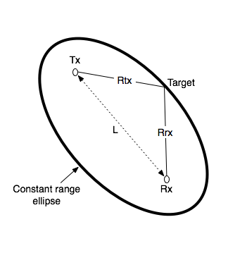
The term “bistatic range” refers to the basic measurement of distance calculated by a radar or sonar system with separated transmitter and receiver. The receiver measures separately the time for the arrival of the signal directly from the transmitter and the time for the arrival of the reflection from the target, and then measures the time difference between the two. This data defines an ellipse of constant bistatic range, called an iso-range contour, on which the target lies, with foci centred on the transmitter and receiver.

Illustration of bistatic range by Paul Howland (Source: Wikimedia Commons)

If the target is at range Rrx from the receiver and range Rtx from the transmitter, and the receiver and transmitter are a distance L apart, then the bistatic range is Rrx+RtxL. Motion of the target causes a rate of change of bistatic range, which results in bistatic Doppler shift.

Malaysia Airlines MH370 change of course (Source: fox6now.com)

On Wednesday, March 12, 2014, the Malaysian military acknowledged that it had recorded radar signals from the location where the missing Malaysia Airlines Flight MH370 was last contacted by ground controllers, hypothetically indicating the aircraft might have changed its path from its northeastward course toward Beijing towards the west.

The Military radar detected an unidentified aircraft at several points, apparently headed west across the Malaysian peninsula and out into the Indian Ocean. The last detected point was hundreds of miles to the west of where search and rescue efforts were initially focused.

On Saturday when the aircraft went missing, the military took no immediate action to investigate the unidentified blips, whose path appeared to take the aircraft near the heavily populated island of Penang.

A senior US official told CNN that Malaysian authorities believe they have several “pings” from the airliner’s Aircraft Communications Addressing and Reporting System (ACARS), transmitted to  the satellites in the four to five hours after the last transponder signal, suggesting the plane flew to the Indian Ocean.

The Military officials then realized the significance of blips on their radar.

If Malaysia Airlines Flight MH370 crashed into the vast expanse of the Indian Ocean with depths of more than 23,000 feet (7,000 meters), the task faced by searchers would be indomitable like finding a needle in a haystack.

India joined the multi-national search operations and has stepped up its search deploying three aircraft and three ships in the region around Andaman and Nicobar Islands.

.

.

RELATED ARTICLES

.

Add this anywhere