
.
Previous: The Paravars: Chapter 2 – The Jewish Lore
.
The most ancient sources of pearl, the queen of jewellery, are believed to be the Persian Gulf, the Red Sea and the Gulf of Mannar which lies between India and Sri Lanka. Pre-historic people of these regions were probably the first to find the first pearls known to mankind, obviously during their quest for food. However, pinpointing the exact region where the discovery and appreciation of pearls first began may be difficult.
In 315 BC, the Greek philosopher Theophrastus, pupil and successor of Aristotle in the Peripatetic school wrote that pearls came from the waters off the coast of India, and certain islands in the Red Sea and in the Sinus Persicus (Persian Gulf).
Megasthenes, the Greek geographer and writer, who accompanied Alexander’s general Seleucus Nicator in his Asiatic conquests, visited many regions of India, including Madurai, the capital of the Pandya kingdom. While in southern India, he also learnt about the neighbouring island of Sri Lanka which he called “Taprobane,” and its valuable resources, such as pearls and a variety of gemstones. Subsequently, in his famous work “Indica” he wrote that Taprobane was an important source of large pearls.
The Alexandrian-Roman geographer, Claudius Ptolemy ( c. AD 100 – c. 170) wrote about the pearl fishery in the Gulf of Mannar, both on the South Indian side and the Sri Lankan side.
The Periplus Maris Erythraei (Periplus of the Erythrian Sea), written by an unknown Alexandrian-Greek author, in the second half of the 1st-century A.D (approximately 60 A.D.), mentions the route to the east coast of India, is through the Gulf of Mannar, between India and Sri Lanka. It provides an extensive account of the pearl fishery in the Gulf of Mannar, particularly on the Indian side of the Gulf, and the pearl fishery of Epidprus (Mannar Island) on the Sri Lankan side of the Gulf.
.
The Gulf of Mannar

.
The Gulf of Mannar is a large shallow bay, a part of the Lakshadweep Sea. It lies between the southeastern tip of India and the west coast of Sri Lanka. The estuaries of the river Thamirabarani of south India and the Malvathu Oya (Malvathu River) of Sri Lanka drain into the Gulf of Mannar.
Geological evidence suggests that in ancient times India and Sri Lanka were connected by land. An 18-mile (30 km) long isthmus composed of limestone shoals, and coral reefs, popularly known as Adam’s Bridge or Rama’s Bridge or Ramsethu, lies between the Rameswaram Island, off the southeastern coast of Tamil Nadu, India, and the Mannar Island, off the northwestern coast of Sri Lanka. Adam’s Bridge separates the Gulf of Mannar in the southwest from the Palk Strait in the northeast. The sea in the area is very shallow, only three to 30 feet (1 to 10 metres) deep in places, and hinders navigation. Some of the sandbanks are dry. Some claim that up to the 15th century, Adam’s Bridge was completely above sea level and people travelled between India and Sri Lanka on foot. The bridge they say was breached, fissured and the channel deepened by storms when a cyclone devastated the region in 1480.
In ancient times, this coast was known worldwide for its natural pearls. Greeks, Romans and Arabs sought the beautiful pearls harvested in these waters. From the time of the known history of the Tamils, pearl trading became one of the principal sources of revenue for the Tamil kings.
The bed of the Pearl Fishery Coast in the Gulf of Mannar is a fertile breeding ground for pearl oysters. There were two distinct fisheries in the Gulf of Mannar – one on the South Indian coast, the other on the northwestern Sri Lankan coast.
On the Indian side of the Gulf of Mannar, the Pearl Fishery Coast of southern India extended along the Coromandel Coast from Thoothukudi (Tuticorin) to Kanyakumari (Cape Comorin). This fishery coast has been known in different periods of time in various languages as the Cholamandalam coast, Colkhic Gulf, Comorin coast, Coromandel coast, Fishery Coast, Kuru-Mandala coast, Ma’bar coast, Paralia, Pescaria, Fishery coast, Tirunelveli coast, Madura coast, etc. The coast took its name from the presence of natural pearls in the bed which is a fertile breeding ground for pearl oysters.
The pearl banks on the Sri Lankan side of the Gulf of Mannar stretch from the island of Mannar, off the northwestern tip of Sri Lanka, south to Chilaw.
.

.
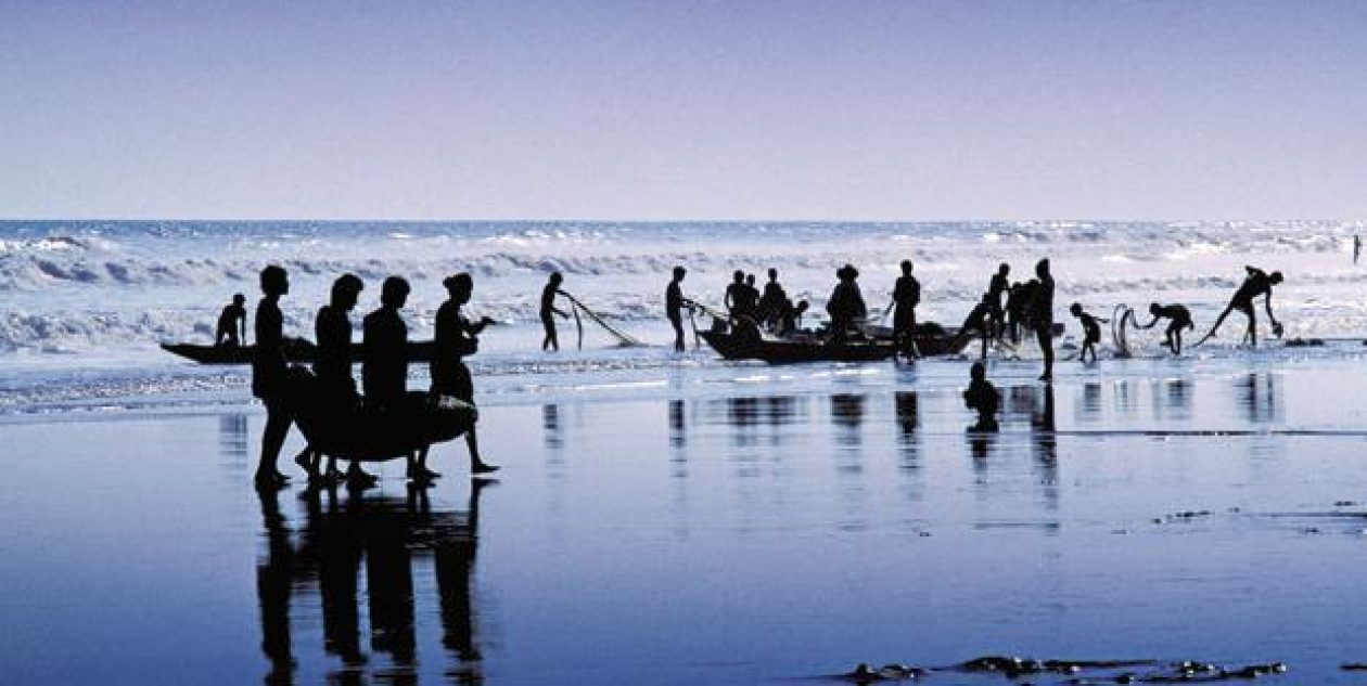
The Pearl Fishery Coast in Southern India and Sri Lanka were predominantly populated by the Paravar caste. The Paravars were fishers, seamen and maritime traders. The majority of the Paravars specialised in the seasonal harvesting of pearl oysters and chank for thousands of years.
The Pandyan kings allowed the Paravars to manage and operate the pearl fisheries because of their ancient skills in that activity, which required specialist seamanship abilities, knowledge of the location of the oyster beds and the art of tending them. The Pandyan kings exempted the Paravars from taxation and allowed them to govern themselves in return for being paid tribute from the harvested oysters.
In ancient times, this Pearl Fishery Coast was known worldwide. Greeks, Romans and Arabs sought the beautiful pearls harvested in these waters by the many Parava fisheries that operated to exploit them. From the time of the known history of the Tamils, pearl trading became one of the principal sources of revenue for the Tamil kings. By the first century AD, pearls and shanks were among the important exports from southern India.
.

.
In the late 1270s, Maravarman Kulasekara Pandyan I sent an expedition to Sri Lanka under his minister Kulasekara Cinkaiariyan Aryachakravarti near the end of the Sri Lankan king Bhuvanaikabâhu I’s reign (1272-1285 AD). Aryachakravarti defeated Savakanmaindan of the Jaffna kingdom, a tributary to the Pandyans. He plundered the fortress of Subhagiri (Yapahuwa) and brought with him the Relic of the tooth of the Buddha. Bhuvanaika Bahu’s successor Parâkkamabâhu III went personally to King Kulasekaran’s court and persuaded him to return the tooth relic.
Most historians agree that on later expeditions it was this Arayachakravarti who stayed behind to create the Arayachakravrati dynasty in the Kingdom of Jaffna and raided the western Sri Lankan coast. From then on, the pearl banks came under the sole dominance of the Aryachakravarti line of kings of the Jaffna kingdom.
Political and military leaders of the same family name left a number of inscriptions in the modern-day Tamil Nadu state, with dates ranging from 1272 to 1305, during the late Pandyan Empire. According to contemporary native literature, the family also claimed lineage from the Tamil Brahmins of Rameswaram in the modern Ramanathapuram District of India.
In 1450, a Tamil military leader named Chempaha Perumal under the directive of the Sinhalese king Sapumal Kumaraya of the Kotte kingdom invaded the region which remained under the control of the Kotte kingdom up to 1467. After that, the region once again came under the Jaffna kingdom.
The Arayachakravrati dynasty ruled the Jaffna kingdom from the 13th until the 17th century, when the last ruler of the dynasty, Sankili II, also known as Sankili Kumaran confronted the Portuguese. Thereafter, the entire pearl fishery on both the Sri Lankan and the Indian side of the Gulf of Mannar came under the exclusive jurisdiction of the Portuguese.
The pearl fisheries of the Gulf of Mannar were controlled independently of one another, by the Pandya, the Chola or by the regional rulers on the Indian side, and by the Sinhalese or Tamil kings on the Sri Lankan side. Sometimes, the two fisheries came under the jurisdiction of the same authorities, such as the Pandyas, the Cholas, the Portuguese (in 1619), the Dutch (in 1658), and the British (1796), whoever controlled the regions on both sides of the Gulf of Mannar.
.
Previous: The Paravars: Chapter 2 – The Jewish Lore
Next: The Paravars: Chapter 4 – The Paravar Caste
.
RELATED ARTICLES
- Pearl hunting (en.wikipedia.org)
- Pearl Fishery Coast (en.wikipedia.org)
- Paravar (en.wikipedia.org)
- Account of the Pearl Fisheries of the North-West Coast of the Island of Ceylon by James Steuart (jstor.org)
- History of the Discovery and Appreciation of Pearls – the Organic Gem Perfected by Nature – Page 1 (internetstones.com)
- History of the Discovery and Appreciation of Pearls – the Organic Gem Perfected by Nature – Page 5 (internetstones.com)
- Mannar Island (en.wikipedia.org)
- Jaffna Kingdom (en.wikipedia.org)
- Yapahuwa (en.wikipedia.org)
- Maravarman Kulasekara Pandyan I (en.wikipedia.org)
- Kulasekara Cinkaiariyan (en.wikipedia.org)
- Cankili II (en.wikipedia.org)
- Dhanushkodi – Fifty Years After the Cyclone of 1964 (tvaraj.com)
- Islands in the Gulf of Mannar: Part 1 – Adam’s Bridge (tvaraj.com)
- Islands in the Gulf of Mannar: Part 2 – The 21 Islands of India (tvaraj.com)
- Islands in the Gulf of Mannar: Part 3 – Islands and Islets of Sri Lanka (tvaraj.com)
- The Paravars: A Preamble (tvaraj.com)
- The Paravars: Chapter 1 – The Hindu Myths (tvaraj.com)
- The Paravars: Chapter 2 – The Jewish Lore (tvaraj.com)
- The Paravars: Chapter 4 – The Paravar Caste (tvaraj.com)
- The Paravars: Chapter 5 – The Pre-Muhammadan Period (tvaraj.com)
- The Paravars: Chapter 6 – The Muhammadan Invasion of the Pandya Kingdom (tvaraj.com)
- The Paravars: Chapter 7 – The Hazardous Occupation of Harvesting Pearl Oysters (tvaraj.com)
- The Paravars: Chapter 8 – Arrival of the Portuguese in India (tvaraj.com)
- The Paravars: Chapter 9 – Seeking Help from the Portuguese (tvaraj.com)
- The Paravars: Chapter 10 – Conversion to Catholicism (tvaraj.com)

Thank you for your wonderful posts on Paravar history. I have been reading these with great interest. I am an Australian and it is very difficult to access information of this sort while living here despite my curiosity. My parents, now deceased, came from South India. My grandmother was born in Mandapam, near Rameswaram in 1885 and her father Lazarus Michael D’Silva b1861 owned a boat and had 20 pearl divers working for him. I do not know the name of the boat, or for how long he was involved with pearl fishing but I know that his main job was in the railways (a very ordinary job) and he gave his daughter 4 houses for her wedding in 1911, so I suppose that he must have been pearling for a while before that. Your impressions, which you have written here have helped me gain a better understanding about the Paravas and pearl fishing, clarity, and I thank you for that.
Just one question, is there a way to access records about my grandfather’s pearling activities? My understanding is that the industry was heavily regulated, so I imagine that there must be records somewhere even though my grandfather would have been small fry with just one boat.
LikeLike
Celeste, I don’t think it would be possible to access records about your grandfather’s pearling activities. Sorry.
LikeLike
Hello Celeste
I have been researching my family tree Lazarus Michael D’silva was my great uncle. He had a child called Agnes Grace d’silva who is my great grandmother
I would love to get in contact with you. My email address is jaymanward@outlook.com
I hope to hear from you soon
Jason
LikeLike